
At low altitudes both wind speed and direction can change abruptly. This jeopardises many anticipated applications for small drones in urban areas. Thanks to catalyst funding from the SESAR JU knowledge hub, Engage, NLR and AirHub started the METSIS project to provide drone operators with accurate weather knowledge.
In the past decade, drones have enjoyed tremendous media attention. The growing excitement for these new aircraft types have led many to envision a future in which large numbers of drones fly over urban areas for numerous applications ranging from aerial photography to package delivery. But before this vision for the future can become a reality, several challenges need to be tackled including safe airspace integration. To this end, in 2017 the SESAR JU initiated the U-space research and innovation programme to develop the services needed to cope with the anticipated future high demand for drone flights.
Accurate knowledge
The Meteo Sensors in the Sky (METSIS) project addresses ‘Weather Information’ service of U-space, which is intended to provide drone operators with information about the actual and forecasted weather situation. Accurate knowledge of the weather, and particular wind, is important because drones, particularly small light weight designs, can be vulnerable to wind. This is often the case at low altitudes where both wind speed and direction can change abruptly. However at present, real-time and accurate knowledge of low altitude wind information is limited, especially in urban areas. This limitation makes it difficult to realize the numerous anticipated applications of small drones in urban areas.
Concept
As a step towards addressing this problem, today NLR – Royal Netherlands Aerospace Centre and AirHub B.V have initiated the Meteo Sensors In the Sky (METSIS) project. METSIS tested the use of drones as a wind sensor network for hyper-local wind now-casting at low altitudes (<1000ft ). The project contributes towards the SESAR U-space programme, which aims to develop the services necessary for integrating drones into European airspace.
The METSIS concept consists of three steps:
- As a first step airborne drones measure instantaneous wind states and transmit data to a ground station;
- Secondly ground station estimates the 3D wind field over the sensed area in real time. Here dashed arrows are ground station estimates and solid arrows are drone measurements;
- Finally the ground station communicates wind field data to drone operators via the U-space weather information service.
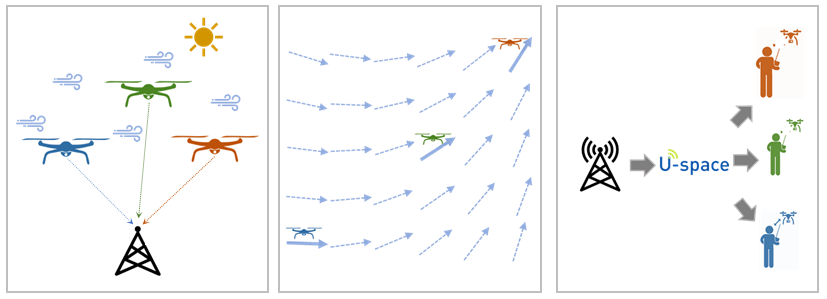
The three steps illustrated: measure wind and transmit data to a ground station (step 1), the ground station estimates the 3D wind field (step 2), and the drone operators receive the weather information (step 3).
All three steps of the METSIS concept will be validated in this project through a series of test flights at the NLR Drone centre in Marknesse, the Netherlands. This unique facility has its own dedicated airspace (up to 3500 ft), and has all the permissions and equipment required to perform experimental drone test flights. Here, NLR will focus on executing the flight tests and validating the accuracy of the underlying algorithms in the presence of static obstacles. AirHub will focus on communicating the estimated wind information to drone operators in real-time via their Drone Operations Centre software.
Dr. ir. Emmanuel Sunil, R&D engineer NLR and project coordinator of METSIS said: “The low altitude wind information determined by the METSIS concept can be used for calculating unsafe no-fly zones, as well as for flight planning by drone operators to improve efficiency as wind can have a significant effect on range. Beyond drones, this information has several other applications including for Shipboard Helicopter Operational Limitation (SHOL) analysis, for offshore construction of wind turbines, and as an additional input to national meteorological forecast systems”.
Participation
The METSIS project has a duration of 1 year, and it is expected to be completed by July 2021. The Royal Netherlands Meteorological Institute (KNMI) and the Delft University of Technology (TU Delft) participate in METSIS project in an advisory capacity.